| |
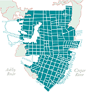
Maps
of the Development of Charleston
We have compiled antique maps to present Charleston's
development in a single layered graphic image. Click the link
at right to launch.
Passing the mouse over the titles will change
the map, showing the growth of the peninsula city from 1673
through the present.
|
|
|
|
| |
Panoramic
Mapping
"The panoramic map was a
popular cartographic form used to depict U.S. and Canadian
cities and towns during the late nineteenth and early twentieth
centuries. Known also as bird's-eye views, perspective maps,
and aero-views, panoramic maps are nonphotographic representations
of cities portrayed as if viewed from above at an oblique
angle. Although not generally drawn to scale, they show street
patterns, individual buildings, and major landscape features
in perspective." - Library of Congress Web Site
Panoramic
Maps Collection At The Library of Congress
Worth a look if you like maps.
Searchable index contains most small to medium sized U.S.
cities. The panoramic maps are downloadable and can be viewed
with the plug-in "MrSID". This program lets you
view a huge photograph at 22 to 1 compression, and only shows
the screen area at high resolution. MrSID also will export
the whole or portions of the image to .TIF files.
|
|
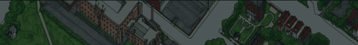
Bird's eye view of the
city of Charleston, South Carolina
1872. Drawn and published by C. Drie.
View Drie's Map of Charleston
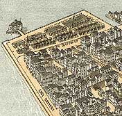
Detail from Bird's eye view of the city
of Charleston, South Carolina 1872. Drawn and published
by C. Drie.
|
|
| |
Antique
Maps of Charleston
These maps will appear in pop-up
windows- load times take about 20 to 30 seconds.
(1739)
The Ichnography of Charles-Town at High Water.
(1780)
Sir Henry Clinton's Map.
(1788)
Plan of the City of Charleston, South Carolina from a Survey
taken by E. Petrie 1788.
(1788)
Ichnography of Charleston, South Carolina.
(1844)
Plan of the City Neck of Charleston, SC.
(1849)
Plan of Charleston S.C.
(1855)
The City of Charleston South Carolina.
(1883)
Composite Map of Charleston.
|
|
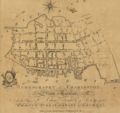
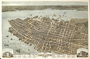
From Ichnography of Charleston,
South Carolina. 1788
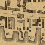
Detail from Ichnography of
Charleston, South Carolina. 1788
|
|